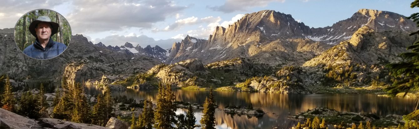
Green River – Porcupine Pass Loop, Wind River Range

Please consider subscribing to my YouTube Channel
https://www.youtube.com/watch?v=G-xI0t6LpT4

https://youtu.be/G-xI0t6LpT4 This is a seven day backpacking trip in the northern section Bridger Wilderness, which consists of 428,000 acres in the Bridger Teton National Forest in the Wind River Range, Wyoming. The trip begins at the Green River Lakes Trail Head then up Highline Trail to Trail Creek Park. From there it’s Clark Creek Trail to Porcupine Creek Trail and over Porcupine Pass. And then continuing on the Porcupine Creek trail to Lakeside Trail back to Green River Lakes Trail Head. https://youtu.be/G-xI0t6LpT4

Gragg Prong – Pisgah NF

Please consider subscribing to my YouTube Channel
https://www.youtube.com/watch?v=v9A32iPKrXE

This is a three night backpacking trip in Pisgah National Forest starting on the Mountains-to-Sea Trail at the junction of Roseboro Road (SR 1511) and then following Gragg Prong. On the second day I leave MTS and continue up Lost Cove Creek Trail. After an easy day on Lost Cove Creek, I climb up Bee Mountain on the fourth day and then drop back down to the Roseboro Road junction.

Boulder Canyon – Blueberry Lake Loop, Wind River Range

Please consider subscribing to my YouTube Channel
https://www.youtube.com/watch?v=D3bwKm9p43g

https://youtu.be/D3bwKm9p43g This is a six day solo backpacking trip in Bridger Wilderness in the Bridger Teton National Forest in the Wind River Range, Wyoming. The trip starts at the Boulder Lake trail head and continues up Boulder Canyon. Once out of the canyon I take Lake Ethel Trail to Highline Trail and then Blueberry Lake Trail back to the Boulder Lake trail head. Thanks for Watching! https://youtu.be/D3bwKm9p43g

Hanging A Bear Bag – 2CR Method

Please consider subscribing to my YouTube Channel
https://www.youtube.com/watch?v=T9L4ORK62oM

https://youtu.be/T9L4ORK62oM This video is a description of hanging a bear bag using two cords and a ring (2CR method). The line used to throw over the limb (“Throw Line”) is about 50 feet of 1.75 MM Zing It cord which can be found at this link: http://www.samsonrope.com/Pages/Produ… The line that goes through the ring and used pull up the food bag (“Pull Line”) is about 30 feet of 2 MM Aircore Spectra Plus, which can be hard to find so any 2 MM utility cord will work. I prefer a 2 MM utility cord as a Pull Line since it’s easier on the hands than the Zing It cord. On one end of the Throw Line is attached a stainless steel ring (a carabiner or pulley can be used instead of a stainless ring) using a figure 8 loop and then the loop is girth hitched to the steel ring. On the other end of the Throw Line is attached a stainless steel #0 Nite Ize S-Biner using a slip knot loop and then the loop is girth hitched to #0 S-Biner. On one end of the Pull Line is attached a stainless steel #1 Nite Ize S-Biner using a figure 8 loop and then the loop is girth hitched to the #1 S-Biner. On the other end of the Pull Line is tied a figure 8 loop. Below is a step by step instruction for the 2CR bear bag system: 1. Unwind both cords and lay untangled on the ground. 2. Run the #1 S-Biner attached to one end of the Pull Line through the ring, which is attached to one end of the Throw Line. 3. Temporarily wrap both ends of the Pull Line around a tree, log or something heavy, and then clip the figure 8 loop to the #1 S-Biner. 4. Put a baseball sized rock or several small rocks into the rock bag. Attach the rock bag to the #0 S-Biner attached to one end of the Throw Line and throw the rock bag over a limb or fork of a tree. 5. Remove the rock bag from the Throw Line and pull the Throw Line to adjust the height of the ring as necessary and then tie off the end of the Throw Line to a tree by wrapping the Throw Line around the tree and clipping the #0 S-Biner to the Throw line rather than using a knot. 6. Unclip the Pull Line from the tree by un-attaching the figure eight loop from the #1 S-Biner. Now attach the food bag to the #1 S-Biner, pull up the food bag to the ring and tie off the other end of the Pull Line to a tree. Make sure the food bag is at least 10 feet high, I prefer 12 feet, and make sure there are no limbs or trees within 6 feet of the food bag, a 10 foot clear area is even better. 7. Whenever you lower and remove the food bag always attach the #1 S-Biner on the Pull Line to the figure 8 loop on the other end on Pull Line, again creating a large loop out of the Pull Line, so that the Pull Line cannot be pulled through the ring accidently. 8. Before removing the Throw Line from the limb detach the #0 S-Biner from the end of the Throw Line and untie the slip knot. Sometimes adjusting the height of the ring is a trial and error process, so you may have to untie the Throw Line and adjust the height of the ring and re-tie off the end of the Throw Line. Also I prefer to use a #1 S-Biner on the Pull Line to save weight. If the food bag or food bags cannot be clipped directly to the #1 S-Biner, run the Pull Line through the loop or cord on the food bag(s) and then clip the #1 S-Biner to the Pull Line above the food bag(s). The video about hanging a bear bag using the PCT method can be seen here: https://www.youtube.com/watch?v=qgBLD… April 2017 Update: I’ve replaced the steel ring with a link from a small chain and now have the system down to 2.5 ounces. My video showing this small chain link can be seen at 2:14 in this video:https://www.youtube.com/watch?v=v5WCm…. In some designated wilderness areas, national parks and state parks bear canisters are required. Therefore hanging your food bag from tree or limb would not comply with the regulations in such areas. https://youtu.be/T9L4ORK62oM

Elkhart Park – Lester Pass Loop, Wind River Range

Please consider subscribing to my YouTube Channel
https://www.youtube.com/watch?v=ZYzkk66Dl4w

https://youtu.be/ZYzkk66Dl4w This is a seven day backpacking trip in northern section Bridger Wilderness, which consists of 428,000 acres in the Bridger Teton National Forest in the Wind River Range, Wyoming. The trip begins at Elkhart Park on the Pole Creek Trail then up to Island Lake and Titcomb Basin. Next over Lester Pass to Pole Creek Lakes and then down to Middle Sweeney Lake. On the last day it’s back to Elkhart Park. https://youtu.be/ZYzkk66Dl4w

Bridger Wilderness From Big Sandy, Wind River Range

Please consider subscribing to my YouTube Channel
https://www.youtube.com/watch?v=U7I3jI59NQ0

https://youtu.be/U7I3jI59NQ0 This is a five night backpacking trip in Bridger Wilderness, which consist of 428,000 acres in the Bridger Teton National Forest in the Wind River Range, Wyoming. The trip begins at Big Sandy Trail Head then up to Iron Creek Meadows to the Highline Trail. Then taking the Francis Lake Trail to Fish Creek Park. After two days in Fish Creek Park I take the Fremont Trail to Diamond Lake Trail up to V Lake. On my final day I take Diamond Lake Trail to the Freemont Trail and then back to Big Sandy Trail Head. https://youtu.be/U7I3jI59NQ0

Osage Mountain to Rabun Bald on the Bartram Trail

Please consider subscribing to my YouTube Channel
https://www.youtube.com/watch?v=OPVVNiJzsfw

http://youtu.be/OPVVNiJzsfw A three night backpacking trip on the Bartram Trail starting on NC State Route 106 at the Osage Mountain Overlook and going south on the Bartram Trail to Rabun Bald in Georgia, and then back to NC SR 106. The southern terminus of the Bartram Trail is on GA SR 28 at Russell Bridge in Rabun County, Georgia. The trail continues north for 37 miles in Georgia and then enters North Carolina and continues for 62 miles ending on Cheoah Bald. http://youtu.be/OPVVNiJzsfw

Seven Brothers Lakes in Cloud Peak Wilderness

Please consider subscribing to my YouTube Channel
https://www.youtube.com/watch?v=hYZe1vtgLz0

http://youtu.be/hYZe1vtgLz0 Seven Brothers Lakes are located in the south east part of Cloud Peak Wilderness, which is comprises a 189,000 acres stretching for 27 miles along the backbone of the Bighorn Mountains in Wyoming. This is a five day solo backpacking trip around Seven Brothers Lakes and up to the Solitude Trail. http://youtu.be/hYZe1vtgLz0

Circle Park in Cloud Peak Wilderness

Please consider subscribing to my YouTube Channel
https://www.youtube.com/watch?v=1BC8wIPTKyA

http://youtu.be/1BC8wIPTKyA Circle Park is located in the south east part of Cloud Peak Wilderness, which is comprises a 189,000 acres stretching for 27 miles along the backbone of the Bighorn Mountains in Wyoming. This is a five day backpacking trip around Circle Park and the adjoining trails. http://youtu.be/1BC8wIPTKyA
1 2 3 4 5 8